 One app for all your study abroad needs


One of the essential topics in the class 9 Geography syllabus is ‘The Physical Features of India.’ It includes the careful study of the geological structure of the country as displayed in the physical features of the Indian map. The study highlights the underlying geological structure of India and also looks into the fact of what makes the country so diverse and different. In this blog, we have highlighted the physical features of India Class 9 to help in your revision!

This Blog Includes:
- Introduction to the NCERT Class 9 Geography Chapter 2: Physical Features of India
- The Himalayan Mountains
- The Northern Plains
- The Peninsular Plateau
- The Indian Desert
- The Coastal Plains
- The Islands
- Important Questions of Chapter 2 Physical Features of India
- Extra Questions of Chapter 2 Physical Features of India
- FAQs
Revise CBSE Notes Class 6 Geography
Introduction to the NCERT Class 9 Geography Chapter 2: Physical Features of India
India is not only a culturally but also a geographically diverse country. The country has mountains, plains, and plateaus to islands and deserts, and the physical features of India are very vast and diverse. If we see the formations of the physical features of the country we can also understand the ‘Theory of Plate Tectonics’. The theory states that the movement of these plates resulted in folding and faulting in continental rocks and volcanic activity. This occurred due to 3 types of plate movements:
- Divergent
- Convergent
- Transform
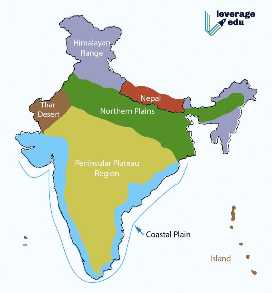
Physical Divisions of India
The physical features of India can be divided into geological and physiological divisions. While the former consists of the Peninsular Block, Indo Ganga-Brahmaputra plain, and the Himalayas. The Physiographic Divisions have 6 major divisions:
- The Himalayan Mountains
- The Northern Plains
- The Peninsular Plateau
- The Indian Desert
- The Coastal Plains
- The Islands
Also Read: NCERT Class 6 Geography: Chapter 6 Our Country – India
The Himalayan Mountains
The Himalayas are mountain barriers that stretch over the borders of northern India. These are some of the most rugged and loftiest mountains of the world and are one of the major landforms of the earth. The Himalayas form an arc that covers a distance of 2,400 Km.
Parallel Ranges of the Himalayas
The Himalayas primarily consist of three parallel ranges that are further divided into:
- Great or Inner Himalayas or the ‘Himadri’: Perennially snowbound, the Great Himalayas have the loftiest peaks. The Himadri has an average height of 6,000 meters and consists of all the major Himalayan Peaks. It is one of the most prominent physical features of India.
- Himachal or Lesser Himalaya: The more rugged part of the mountain range that is also called the lesser Himalaya or Himachal. This area of Himachal is widely known for its beautiful hill stations. These ranges have an average height of 3700 to 4500 meters. Pir Panjal is the longest range.
- Outer Himalayan Range or Shiwaliks: These are comparatively lower ranges, with altitudes varying from 900 to 1,100 meters. They comprise the unconsolidated sediments that get brought down by rivers from the Himadri ranges.
- Duns: The longitudinal valley lying between the lesser Himalayas and the Shiwaliks is known as Duns. Dehra Dun, Kotli Dun, and Patli Dun are some of the well-known Duns.
Check out Himalaya ka Paryayvachi Shabd
Regional Classification of the Himalayas
The Himalayas are also divided on the basis of regions from west to east:
- The part of the Himalayas lying between the Indus and Satluj has been traditionally known as Punjab Himalaya but it is also known regionally as Kashmir and Himachal Himalaya from west to east respectively.
- . The part of the Himalayas lying between the Satluj and Kali rivers is known as Kumaon Himalayas.
- The Kali and Tista rivers demarcate the Nepal Himalayas and the part lying between Tista and Dihang rivers is known as Assam Himalayas.
- The Brahmaputra marks the easternmost boundary of the Himalayas.
The Northern Plains
The three major river systems, the Indus, the Brahmaputra, and the Ganga have resulted in the formation of the northern plain. Spreading over 7 lakh sq. km, it is a vast area of alluvial soil.
The northern plain is divided into the following 3 sections:
- The Western part of the Northern Plain is referred to as the Punjab Plains.
- The Indus and its tributaries–the Jhelum, the Chenab, the Ravi, the Beas, and the Satluj originate in the Himalayas.
- The Ganga plain extends between the Ghaggar and Teesta rivers.
- It is spread over the states of North India, Haryana, Delhi, U.P., Bihar, partly Jharkhand, and West Bengal to its East, particularly in Assam lies the Brahmaputra plain.
The physical features of India, in context to the northern plans, have been given a rundown below:
| Relief Features of Northern Plains | Description |
| Bhabar | It is a narrow 8 KM to 16 KM wide range of boulders and pebbles. It is in the foothills of Shivaliks or the outer Himalayan range. In this, the streams disappear. |
| Khadar | The more fertile part of the plains, this region comprises newer and younger deposits of alluvial soil. |
| Bhangar | This is the largest part of the Northern Plain, which is formed of older alluvial soil. It forms a terrace-like structure that lies above the floodplains. The soil here consists of calcareous deposits called “Kankar” |
| Terai | The Terai region is wet and swampy. It is created by the rivers when they re-emerge. The thickly-forested Dudhwa National Park is located here. |
The Peninsular Plateau
The Peninsular Plateau defines the physical features of India. It is mainly composed of old igneous, crystalline, and metamorphic rocks and is also one of the oldest land masses. The three major divisions of the Plateaus are the Central Highlands, the Deccan Plateau, and the NE Plateau.
The Central Highlands
Spreading over the major area of the Malwa Plateau, The Central Highlands lie next to the north of the Narmada River. If you look closely at the physical features of the Indian map, you will find that these highlands are narrower in the east and broader in the west.
The Deccan Plateau
The Deccan Plateau forms a broad base of a triangular landmass that falls to the south of the Narmada River. The Satpura range, the Kaimur hills, and the Maikal range form its eastern extensions as can be seen in the physical features of the India map. Furthermore, the slope moves gently eastwards.
NE Plateau
Also called Meghalaya/Karbi-Anglong Plateau/N-central Chachar Hills, this is the extension of the main peninsular plateau.
| Western Ghats | Eastern Ghats |
| Western Ghats lie parallel to the western coast. | The Eastern Ghats stretch from the Mahanadi Valley to the Nilgiris in the south |
| Their average elevation is 900– 1600 meters | Their average elevation is 600 meters |
| The Eastern Ghats are discontinuous and irregular and dissected by rivers draining into the Bay of Bengal | The Western Ghats cause orographic rain by facing the rain-bearing moist winds to rise along the western slopes of the Ghats. |
| The highest peaks include the Anai Mudi (2,695 meters) and the Doda Betta (2,637 meters). | Mahendragiri (1,501 meters) is the highest peak in the Eastern Ghats |
Quick Fact: The point at which the Eastern and Western ghats meet, it is called the Deccan Trap. Bering is volcanic in nature, it has black soil and igneous rocks.
The Indian Desert
- The entire expanse of the Indian desert lies in the western margins of the Aravali hills (demarcated in the physical features of the India map).
- It is covered in sandy plains and dunes, this region receives rainfall below 150 mm every year.
- Hence, there is minimal vegetation cover. The largest river that flows here is Luni.
The Coastal Plains
The coastal plains are narrow stretches of land across the Arabian Sea and Bay of Bengal. As seen on the physical features of India map, the Coastal Plains in the southern part are broadly divided into, The Konkan, The Kannada Plain, and the Malabar coast. On the eastern side, across the Bay of Bengal, the plains are further classified into Northern Circar and the Coromandel Coast. Tabulated below are some of the major differences between the western and eastern coastal plains:
| Western Plains | Eastern Plains |
| Narrow | Broad |
| Submerged Plain | Emerged Plain |
| Rivers don’t form Deltas here | Well Developed Deltas |
The Islands
India mainly comprises two major Island groups, the Lakshadweep Islands in the Arabian Sea and The Andaman and Nicobar Islands. The Andaman Island groups include 204 smaller islands. Furthermore, the A&N islands are divided by 10-degree channels.
The group of islands are further divided into two sections:
- Andaman in the North
- Nicobar in the South
These islands are close to the equator, have thick forest covers and experience an equatorial climate
- There is a great diversity of flora and fauna in this group of islands.
- These islands lie close to the equator and experience an equatorial climate.
- This island group has a great diversity of flora and fauna. thick forest cover.
Download NCERT Solutions Class 8 Geography Chapter 1 Resources (Free PDF)
Important Questions of Chapter 2 Physical Features of India
1. Choose the right answer from the four alternatives given below.
(i) A landmass bounded by the sea on three sides is referred to as
(a) Coast
(b) Island
(c) Peninsula
(d) None of the above
Answer: (c)
(ii) Mountain ranges in the eastern part of India forming its boundary with Myanmar are collectively called
(a) Himachal
(b) Uttarakhand
(c) Purvachal
(d) None of the above
Answer: (c)
(iii) The western coastal strip, south of Goa is referred to as
(a) Coromandel
(b) Konkan
(c) Kannad
(d) Northern Circar
Answer: (c)
(iv) The highest peak in the Eastern Ghats is
(a) Anai Mudi
(b) Kanchenjunga
(c) Mahendragiri
(d) Khasi
Answer: C
2. Answer the following questions briefly.
(i) What is the bhabar?
Answer:
The northern plains are generally described as flatlands, with no variations in their relief. However, that is not true. These vast plains also have diverse relief features. According to the variations in relief features, the northern plains can be divided into four regions. The rivers, after descending from the mountains, deposit pebbles in a narrow belt of about 8 to 16 km in width lying parallel to the slopes of the Shiwaliks. This region is known as bhabar.
(ii) Name the three major divisions of the Himalayas from north to south.
Answer:
- The northernmost range is known as The Great or Inner Himalayas or Himadri.
- Himachal or Lesser Himalaya.
- Outer Himalayas or Shiwaliks.
(iii) Which plateau lies between the Aravali and the Vindhya ranges?
Answer:
The Malwa plateau lies between Aravali and Vindhya ranges.
(iv) Name the island group of India having a coral origin.
Answer:
The Lakshadweep Islands is the island group of India having a coral origin.
3. Distinguish between
(i) Bhangar and Khadar
Answer:
Bhangar
- Lies above flood plains of the river.
- Older alluvium or old soil and forms the largest part of the northern plains.
Khadar
- It is a newer, younger deposit of flood plains. It is renewed every year.
(ii) the Western Ghats and the Eastern Ghats
Answer:
The Western Ghats
- Lie parallel to the Western Coast.
- They are continuous and can be crossed through passes only.
- The Western Ghats’ average elevation is 900 – 1600 metres.
- The Western Ghats cause orographic rain by facing the rain-bearing moist winds to rise along the western slopes of the Ghats.
- The height of the Western Ghats progressively increases from north to south.
The Eastern Ghats
- Lies parallel to the Eastern Coast.
- They are discontinuous and irregular.
- The Eastern Ghats are dissected by rivers flowing into the Bay of Bengal.
- The Eastern Ghats average elevation is 600 metres.
4. Which are the major physiographic divisions of India? Contrast the relief of the Himalayan region with that of the Peninsular plateau
Answer:
The major physiographic divisions of India are
- The Himalayan Mountains
- The Northern Plains
- The Peninsular Plateau
- The Indian Desert
- The Coastal Plains
- The Islands
Contrast the relief of Himalayan region and Peninsular Plateau
Geologically, the Peninsular Plateau constitutes one of the ancient landmasses on the earth’s surface. It was supposed to be one of the most stable land blocks. The Himalayas are the most recent landforms. From the viewpoint of geology, Himalayan mountains form an unstable zone. The whole mountain system of Himalaya represents a very youthful topography with high peaks, deep valleys and fast-flowing rivers. The northern plains are formed of alluvial deposits. The peninsular plateau is composed of igneous and metamorphic rocks with gently rising hills and wide valleys.
5. Give an account of the Northern Plains of India.
Answer:
The Northern Plains are the most recent landforms. The northern plains are formed of alluvial deposits. The northern plain has been formed by the interplay of the three major river systems, namely — the Indus, the Ganga and the Brahmaputra, along with their tributaries. This plain is formed of alluvial soil. The deposition of alluvium in a vast basin lying at the foothills of the Himalaya over millions of years formed this fertile plain. It spreads over an area of 7 lakh sq. km. The plain being about 2400 km long and 240 to 320 km broad, is a densely populated physiographic division. With a rich soil cover combined with an adequate water supply and favourable climate, it is agriculturally a productive part of India. The Northern Plain is broadly divided into three sections. The Western part of the Northern Plain is referred to as the Punjab Plains. Formed by the Indus and its tributaries, the larger part of this plain lies in Pakistan. The Indus and its tributaries — the Jhelum, the Chenab, the Ravi, the Beas and the Satluj all originate in the Himalaya. This section of the plain is dominated by the doabs. The Ganga plain extends between Ghaggar and Teesta rivers. It is spread over the northern states of Haryana, Delhi, U.P., Bihar and partly Jharkhand. The Ganga plains also extend towards Bengal to it’s east. Further east, in Assam lies the Brahmaputra plain. The northern plains are generally described as flatlands with no variations in their relief. However, this is not exactly true. These vast plains also have diverse relief features. According to the variations in relief features, the Northern plains can be divided into four regions. The rivers, after descending from the mountains, deposit pebbles in a narrow belt of about 8 to 16 km in width lying parallel to the slopes of the Shiwaliks. This region is known as bhabar. All the streams disappear in this bhabar belt. South of this belt, the streams and rivers re-emerge and create a wet, swampy and marshy region known as terai. This was once a thickly forested region, full of wildlife.
6. Write short notes on the following.
(i) The Indian Desert
Answer:
The Indian desert lies towards the western margins of the Aravali Hills. It is an undulating sandy plain covered with sand dunes. This region receives very low rainfall. The average rainfall is below 150 mm per year. It has an arid climate with low vegetation cover. Streams appear during the rainy season. Soon after they disappear into the sand as they do not have enough water to reach the sea. Luni is the only large river in this region.
(ii) The Central Highlands
Answer:
Central Highlands and the Deccan Plateau. The part of the Peninsular plateau lying to the north of the Narmada river, covering a major area of the Malwa plateau, is known as the Central Highlands. The Central Highlands are wider in the west but narrower in the east. The eastward extensions of this plateau are locally known as the Bundelkhand and Baghelkhand. The Chotanagpur plateau marks the further eastward extension, drained by the Damodar river.
(iii) The Island groups of India
Answer:
Lakshadweep Islands
The Lakshadweep group of islands is composed of small coral islands. Earlier they were known as Laccadive, Minicoy and Amindive. In 1973, these were re-named as Lakshadweep. It covers a small area of 32 sq km. The Kavaratti Island is the administrative headquarters of Lakshadweep. This island group has a great diversity of flora and fauna. The Pitti island, which is uninhabited, has a bird sanctuary.
Andaman and Nicobar Islands
The elongated chain of islands located in the Bay of Bengal extends from north to south. These are the Andaman and Nicobar Islands. They are bigger in size and are more numerous and scattered. The entire group of islands is divided into two broad categories – The Andaman in the north and the Nicobar in the south. It is believed that these islands are an elevated portion of submarine mountains. These island groups are of great strategic importance for the country. There is a great diversity of flora and fauna in this group of islands too. These islands lie close to the equator and experience an equatorial climate, and have thick forest cover.
Extra Questions of Chapter 2 Physical Features of India
Due to the physical features of India being so diverse, there is a need to revise and test your knowledge as well! Thus, these are a few questions which you could practice:
- Which is the most fertile part of the northern plains?
- Which part of the Himalayas lies between Indus and Satluj?
- Where does the Brahmaputra plain lie?
- Where is Lake Chilika located?
- The Malabar coast is also referred to: _________
- What is the outermost range of the Himalayas called?
- Which is the highest peak of the Western Ghats.
- The Nicobar lie in the:
- What does the core of the Himadri consist of?
- The Jhelum is a tributary of: ___________
Ans:
- Khadar
- Punjab Himalayas
- The state of Assam
- Eastern Coast
- Southern Stretch
- Shiwalik
- Anamudi
- South
- Granite
- The Indus
📌 Explore Class 7 Geography Notes
FAQs
The 6 physical features of India are mentioned below.
The Himalayan mountains.
Indian Desert.
The Northern Plains.
Peninsular plateau.
Coastal Plains.
Islands.
The Indus, the Brahmaputra, and the Ganga are the three major rivers of the northern plain.
Shiwalik is the outermost range of the Himalayas.
Follow Leverage Edu for more updates and interesting reads on School Education.
-
Wow
-
Thanks Pranjal
-
-
This notes is very important for me
Thanks-
Happy to help!
-

 45,000+ students realised their study abroad dream with us. Take the first step today.


10 comments
Wow
Thanks Pranjal
This notes is very important for me
Thanks
Happy to help!
Thanku
thanks for reading.
Also, check: India Size and Location
Good
Thank you! Glad you enjoyed our blog
My thoughts is like
It is so helpful
Tqqq 😇
Is natural vegetation there too