 One app for all your study abroad needs


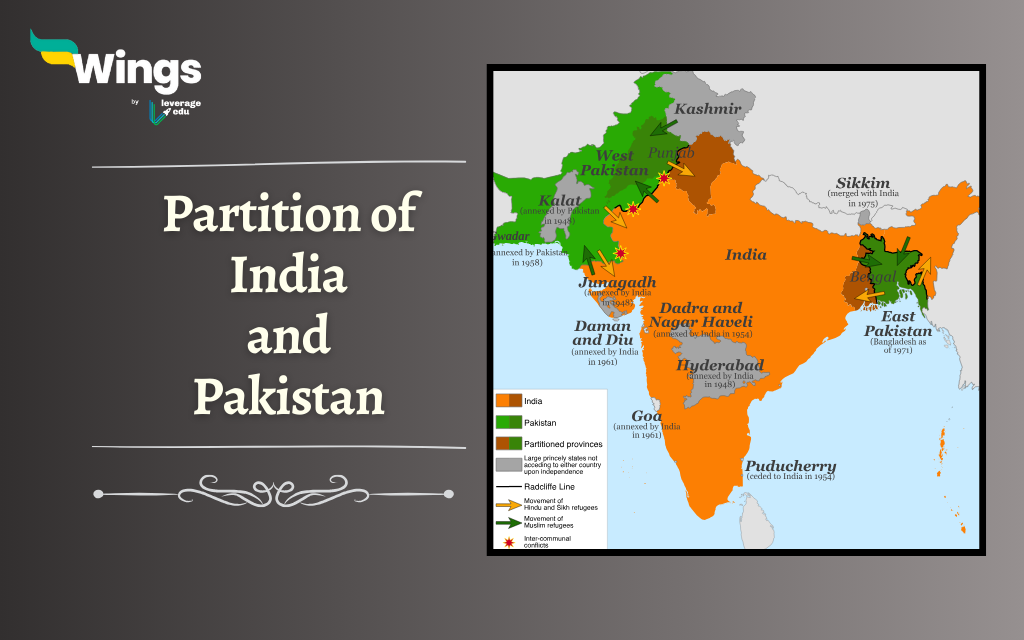
The partition of India and Pakistan killed thousands and uprooted millions. This event left an indelible mark on the lives of millions and it still haunts generations of people. Considered an unjust and inhuman act the division of two nations has inflamed communal disharmony between Hindus and Muslims hitherto. With the partition, the British-ruled India was segregated into India, East Pakistan, and West Pakistan. This separation culminated in several wars between Independent India and Pakistan decades later. Furthermore, the rivalry over Kashmir still haunts the people of the valley and remains the bone of contention between the two nations.

Table of Contents

Indian Independence Act of 1947
The British Parliament passed the Indian Independence Act on July 5, 1947. King George VI of Britain gave his approval on July 18, 1947. This Act removed the title “Emperor of India” from the British Crown, as announced by George VI. Furthermore, the Act included the following features:
- It recognized India as an independent and sovereign nation.
- Also, it provided for the division of the Indian state into two separate dominions, India and Pakistan, due to religious differences.
- Furthermore, the position of the Secretary of State for India was abolished.
- Besides, the role of the Viceroy was eliminated, and two separate Governor Generals were to be appointed for India and Pakistan based on British Cabinet advice.
- In addition, the Indian and Pakistani Constituent Assemblies were authorized by the Act to create their respective constitutions and repeal any British Parliament laws for their countries, including the Independence Act. These Assemblies acted as legislative bodies until their own constitutions were formed.
Also Read: What was the Khilafat Movement?
Radcliffe Commission or Border Commission
Following the Indian Independence Act, the British government instituted the Radcliffe Commission in July 1947 to mark the boundaries between India and Pakistan. The commission was headed by Sir Cyril Radcliffe with 4 members each from the Indian National Congress and Muslim League. The commission’s task was to establish borders in the two regions that would preserve cohesive Hindu and Muslim populations within India and Pakistan. As the August 15 independence date approached and with little hope for agreement, Radcliffe took the final decision on the boundaries.

Radcliffe Line: The Border Between India and Pakistan
The Radcliffe Line, which became the border between India and Pakistan, was unveiled on August 17, 1947. This line stretches from the Rann of Kutch in Gujarat to the international border in Jammu & Kashmir, effectively dividing the two countries. Radcliffe’s division of India resulted in the creation of three segments:
- West Pakistan
- East Pakistan
- India
Also Read: Why Did the Indian Mutiny Happen?
Partition of India and Pakistan
With the demarcation of India and Pakistan through the Radcliffe Line, a territory of 4,50,000 sq km and a population of nearly 88 million was divided on the basis of religion.
- The provinces of Sindh and Baluchistan, where Muslims formed a substantial majority (over 70% and 90% respectively), were assigned to Pakistan.
- However, Punjab and Bengal, with slightly more than half Muslim populations (55.7% in Punjab and 54.4% in Bengal), presented a challenge.
- Although Muhammad Ali Jinnah aimed for these provinces to be part of Pakistan entirely, the Congress Party disagreed, considering the sentiments of the Hindu and Sikh populations.
- As a result, a decision was reached to partition these provinces, allotting portions to both countries.
Also Read: Unveiling the Heroic Role of Women in India’s Freedom Struggle

This division proved to be a daunting task, particularly in Punjab, due to the widespread and mixed population. Drawing a clear religious divide was nearly impossible. Beyond considering the people, the border commissions also had to manage crucial elements such as roadways, railways, power systems, irrigation projects, and individual landholdings. The intention was to minimize the displacement of farmers from their lands and to limit the number of individuals compelled to migrate to the respective sides of the border.
Also Read: Bhagat Singh: Biography, Revolutionary Struggle, Death

However, certain regions posed significant challenges in determining their placement on one side or the other due to unclear majorities, along with factors like cultural ties and irrigation lines. Despite having a Muslim majority, some areas with a narrow margin, like the Muslim-majority tehsils of Gurdaspur district, Ajnala in Amritsar, and Zira and Ferozpur in Ferozpur, were assigned to India.
The Chittagong Hill Tracts, mainly inhabited by non-Muslims (primarily Buddhists) and with limited accessibility to India, were granted to East Pakistan. Similarly, the Khulna district, with a slight Hindu majority of 51%, became part of East Pakistan. Conversely, Murshidabad, where Muslims constituted 70% of the population, was given to India.
Also Read: Swadeshi Movement: Leaders, Timeline, History
Results


#1. Which commission was formed to draw boundaries between India and Pakistan?
#2. When was the boundary between India and Pakistan finalised?
#3. Who headed the Border Commission?
FAQs
The idea behind the creation of Pakistan was based on the notion that Hindus and Muslims were not capable of living together in one country. The British administration backed the proposal for Pakistan, and the separation of India was officially declared on August 15, 1947.
In 1947, Sir Cyril Radcliffe, a civil servant from Britain, was responsible for drawing up the borders between India and Pakistan. The sub-continent was divided into three parts: a central and southern region where the majority of the population was Hindu, and two parts in the north-west and north-east where people were mostly Muslim. The division was not very precise and was done in a rough manner.
On 3rd June 1947, Mountbatten came up with a plan to divide India after several discussions. This plan was referred to as the “Mountbatten Plan” and was accepted by both the Congress leaders and the Muslim League.
Before partition, the region of South Asia, which includes India, Bhutan, Bangladesh, Pakistan, Maldives, Nepal, and Sri Lanka, was known as British India. It was governed by the British East India Company and was under the rule of the British Crown.
If we consider the hypothetical scenario where India has a land area of 4.230 million sq km, it would also have a population of 1.7 billion, making it the largest in the world. Additionally, India would have the largest populations of both Hindus and Muslims, as it currently has the third-largest Muslim population and the largest Hindu population in the world.
Relevant Blogs
This blog was all about the partition of India and Pakistan. If you want to read more articles like this, you can get Short notes on the Modern History of India here. Also, you can visit our general knowledge page on Indian History!