

 One app for all your study abroad needs


- 8°4′ N to 37°6′ N and 68°7′ E to 97°25′ E
- 7°6′ N to 35°4′ N and 69°7′ E to 98°32′ E
- 6°45′ N to 35°50′ N and 67°5′ E to 96°10′ E
- 8°4′ N to 37°6′ N and 68°7′ E to 96°45′ E
Correct Answer: 1. 8°4′ N to 37°6′ N and 68°7′ E to 97°25′ E
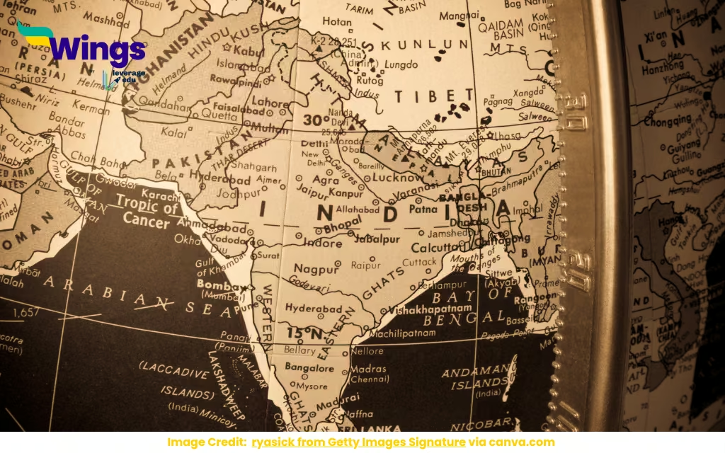
India’s vast size and shape are defined by its latitudinal and longitudinal extent: 8°4′ N to 37°6′ N and 68°7′ E to 97°25′ E. This range covers everything from the Andaman Islands to the Himalayas, making India a geographical marvel. For students, this is a chance to explore India’s diversity, climate, and place on the world map. Let’s unpack what these coordinates mean and why they’re key to understanding India.
India’s Geographical Spread
India’s latitude stretches from 8°4′ N in the Andaman and Nicobar Islands to 37°6′ N in Ladakh, covering about 30 degrees north-south. Longitudinally, it spans from 68°7′ E in Gujarat to 97°25′ E in Arunachal Pradesh, roughly 29 degrees east-west. This makes India huge—about 3.2 million square kilometers! The range includes tropical beaches, Himalayan peaks, and everything in between, shaping its climate and culture.
For students, this is a perfect intro to geography. The coordinates show why India has monsoons in Kerala but snow in Kashmir. You can map these points to see India’s shape or explore how its location near the equator affects its weather. It’s a great way to connect math (coordinates) with geography, ideal for projects or map-making exercises.
Why Coordinates Matter
The latitudinal and longitudinal extent defines India’s place on the globe. Being between 8° and 37° N puts most of India in the tropical and subtropical zones, giving it monsoons, hot summers, and mild winters. The longitudinal spread means India spans multiple time zones, though it uses one standard time (IST, UTC+5:30). These coordinates also affect trade, as India’s location connects it to Asia, Europe, and Africa via sea routes.
Students can use this to explore real-world impacts. How do coordinates affect agriculture or shipping? Why does India have one time zone despite its width? You can research how the Tropic of Cancer (23.5° N) cuts through India, splitting its climate zones. It’s a fun way to tie geography to economics or environmental science, making maps come alive.
Quick Facts
- Extent: 8°4′ N to 37°6′ N, 68°7′ E to 97°25′ E.
- Area: ~3.2 million square kilometers.
- Key Points: Andamans (south), Ladakh (north), Gujarat (west), Arunachal (east).
- Climate Impact: Tropical to subtropical zones.
- Time Zone: IST (UTC+5:30), one for all of India.
- Student Tip: Plot India’s coordinates on a map for practice.
Diversity in India’s Landscape
India’s coordinates cover an incredible range of landscapes. The southern tip at 8°4′ N includes coral islands, while 37°6′ N reaches icy Himalayan peaks. Longitudinally, the western deserts of Gujarat contrast with the lush forests of Arunachal Pradesh. This diversity supports everything from tea plantations in Assam to fisheries in Tamil Nadu, shaping India’s economy and culture.
For students, this is a chance to explore biodiversity and human geography. How do people adapt to deserts versus mountains? You can research national parks like Sundarbans or Himalayan ecosystems for a biology project. It’s also a way to see how India’s geography influences its food, festivals, and languages, perfect for cultural studies or geography assignments.
Challenges of a Vast Extent
India’s huge extent brings challenges. The northern border at 37°6′ N, near disputed areas like Ladakh, faces geopolitical tensions. The eastern and western edges deal with different climates, affecting agriculture and disaster planning (think monsoons versus droughts). Connectivity is another issue—linking remote Andamans to mainland India takes effort. These coordinates show why India’s infrastructure and policies are so complex.
Students can dig into these for critical thinking. How does geography shape border disputes? What’s the impact of climate variation on farming? You can explore how India manages its diversity or research projects like the Golden Quadrilateral to connect its vast extent. It’s a real-world look at geography meeting policy and economics.
How Students Can Explore India’s Geography
Want to get hands-on? Grab a map and plot India’s coordinates—8°4′ N, 37°6′ N, 68°7′ E, 97°25′ E—to see its shape. Online tools like Google Earth can show you the Andamans or Ladakh up close. For a project, compare India’s climate zones or research how its location affects trade routes. NCERT geography books or videos on India’s diversity can break it down.
For fun, plan a “virtual tour” across India’s extremes, from Kanyakumari to Kashmir. Or, quiz your friends on India’s coordinates or key landmarks. India’s latitudinal and longitudinal extent is a gateway to its geography, so let it inspire you to explore the country’s beauty and complexity!
Summary
India’s latitudinal and longitudinal extent (8°4′ N to 37°6′ N, 68°7′ E to 97°25′ E) defines its vast size, from tropical islands to Himalayan peaks. This range shapes its climate, culture, and economy. For students, it’s a chance to explore geography, biodiversity, and real-world challenges, connecting coordinates to India’s diverse story.
Also Read:
Kanchanjunga Peak is located in _______.
The Arvari River, considered the Smallest River in India, is Located in
Which State?
Ajanta and Ellora Caves are located in Which State of India?
Panchavti, a Key Part of the Valmiki Ramayana is located in which State of
India?
The Nagarjuna Sagar Dam is located in Which State?

 60,000+ students trusted us with their dreams. Take the first step today!